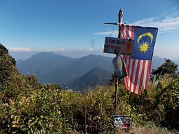
Mount Yong Belar
Appearance
| Mount Yong Belar | |
|---|---|
 Summit of Yong Belar | |
| Highest point | |
| Elevation | 2,181 m (7,156 ft)[1] |
| Prominence | 615 m (2,018 ft)[1] |
| Listing | Spesial Ribu |
| Coordinates | 4°39′00″N 101°21′42″E / 4.65000°N 101.36167°E[1] |
| Naming | |
| Native name | Gunung Yong Belar (Malay) |
| Geography | |
| Location | Lojing Autonomous Subdistrict, Kelantan Kinta District, Perak |
| Parent range | Titiwangsa Mountains |
Mount Yong Belar (Malay: Gunung Yong Belar, Jawi: ڬونوڠ يوڠ بلار) is a mountain on the border of the states Kelantan and Perak in the Titiwangsa Mountains of Malaysia. Its summit is 2,181 m (7,156 ft) above sea level, making it the highest mountain in the state of Kelantan, and the third highest in Peninsular Malaysia, behind Mounts Tahan and Korbu, the latter being located 8 km north.
See also
[edit]References
[edit]- ^ a b c "Southeast Asia: Cambodia, Laos, Thailand, Vietnam and Peninsular Malaysia". Peaklist.org. Retrieved 2015-01-03.
External links
[edit]

